NHAI
AI-Powered Traffic Management System for National Highways
- Data, AI & Analytics

Overview
Established in 1995, the National Highways Authority of India (NHAI) is an autonomous agency under the Government of India, managing over 50,000 km of National Highways. NHAI has embraced AI-driven traffic management solutions to reduce road fatalities and enhance highway operations.
NHAI set a goal to reduce road fatalities and enhance highway operations. To achieve this, they proposed the development of a system that can utilize computer vision, Artificial Intelligence and machine learning to continuously monitor and manage all activities on the highways.
Challenges
The vast expanse of expressways presents complex challenges for traffic management. Smart highway systems are crucial to monitoring aspects such as traffic congestion, passenger safety, traffic offenders, and vehicle compliance. NHAI faced the need for an intelligent system capable of processing data from diverse sources such as IoT-based sensors, CCTV cameras, and traffic management systems.
- Continuous Monitoring and Alert System- In response to escalating highway rule violations and accidents, NHAI required a system that can monitor expressway traffic conditions in real-time, and alert relevant authorities and law enforcement agencies promptly using a dependable monitoring mechanism.
- Data Integration from Diverse Sources- Considering the vast length of expressways and highways, a system was needed that can efficiently gather and process data from a variety of sources such as surveillance cameras, sensors, , and traffic management systems.
- Expressway Safety Event Detection- With the numerous types of rule violations occurring on highways, NHAI required a robust system capable of identifying unsafe incidents on expressways, such as high-speed vehicles, wrong-way traffic, congestion, poor visibility, and stationary traffic.
- Minimize Response Time to Emergency Events- The NHAI required a system to reduce the response time to accidents, casualties, instances of high-speed vehicles, wrong-way driving, and congestion. The goal was to create safer roads for everyone and strengthen the overall safety measures on expressways.
Solution
To address these challenges, NHAI partnered with Auriga IT to develop an AI-powered system for comprehensive highway surveillance and traffic management. By integrating AI algorithms, IoT devices, and smart road sensors, the system enhances highway monitoring, reduces response times in emergency events, and improves overall road safety.
1. Video Incident Detection System- Detects incidents such as wrong-way driving, high-speed vehicles, and roadblocks using AI-powered computer vision.
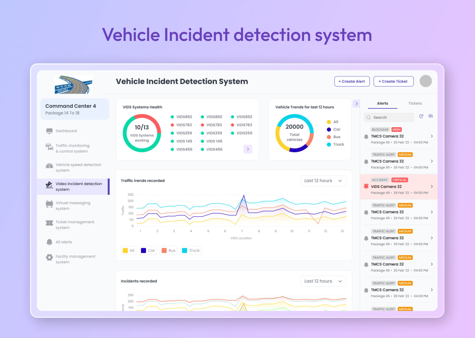
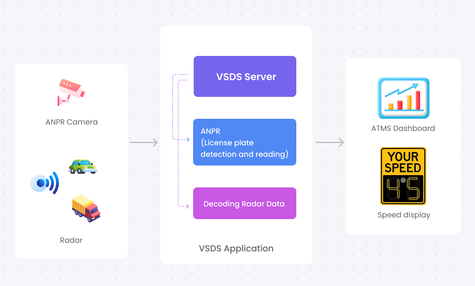
2. Vehicle Speed Detection System- Video Incident Detection System (VIDS): Detects incidents such as wrong-way driving, high-speed vehicles, and roadblocks using AI-powered computer vision.
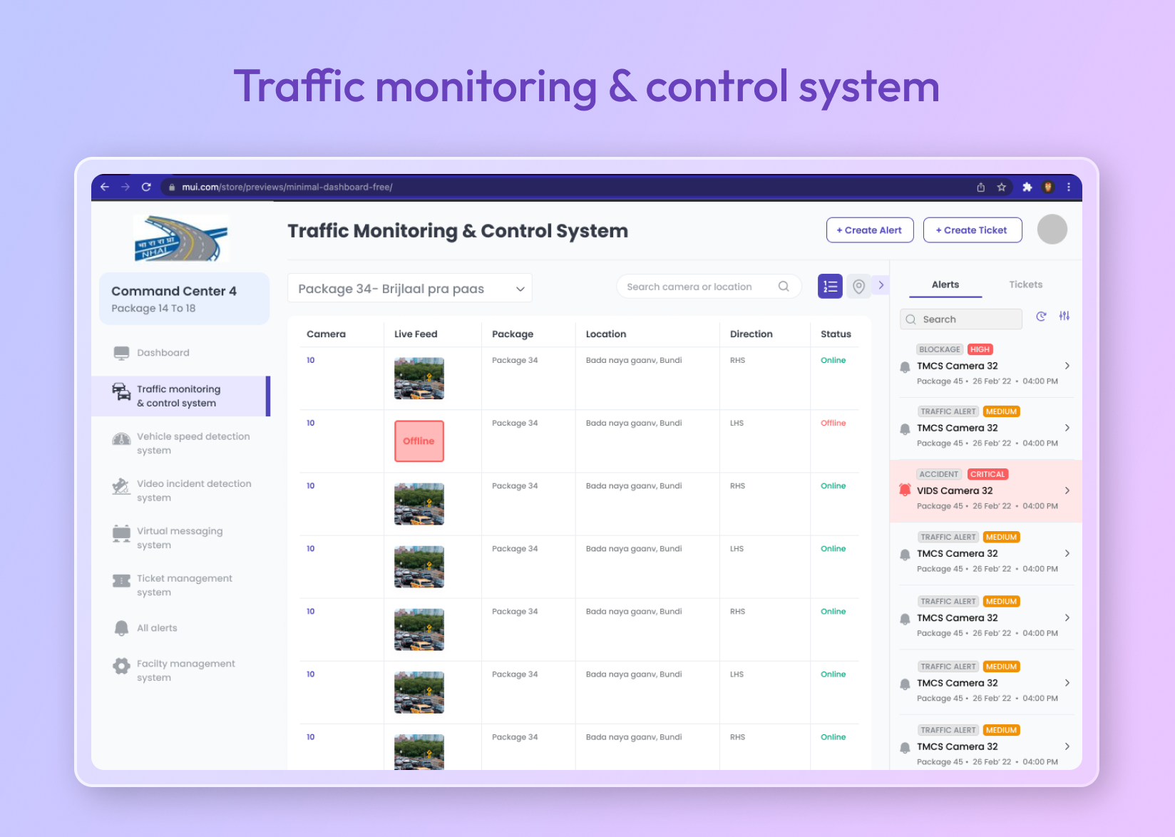
3. Traffic Monitor Camera System- Provides real-time visibility through multiple camera feeds, assisting command center operators in traffic monitoring and control.
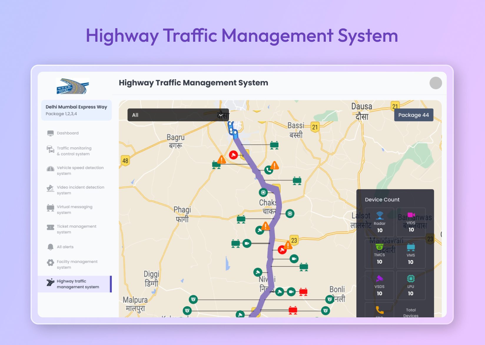
4. Highway Traffic Monitoring System- A comprehensive bird’s-eye view of the entire highway system is provided to the command centre executive through a marker-based representation featured by the system, which represents devices and events on the map. Event markers indicate incidents such as accidents or road closures, and device status indications provide alerts if a system is not functioning properly or is down.
5. Variable Messaging System- A VMS dashboard was developed, enabling command center personnel to view all the signboards on the road and their locations on a map. This tool also allows them to communicate important information, such as traffic alerts, construction updates, and weather warnings, to road-users by sending messages to the signboards. The messages are delivered by connecting to each signboard’s IP address.

6. Facility Management System- This system was developed to streamline essential operations related to various devices, including cameras, VIDS devices, and radar systems. With the implementation of this system, the ability to seamlessly access a real-time view of available devices, monitor their health status, and execute commands across all integrated devices within the system is granted to personnel stationed at a command center.
7. Event Management Module– Traffic jams are automatically detected by the system by comparing the real-time speed of vehicles. Events are manually registered by operators after verification through various methods, which include the use of patrol vehicles and camera detection from systems such as TMCS, VIDS, ANPR, VSDS, etc., as well as other sources of information.
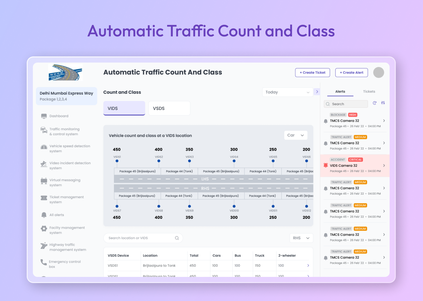
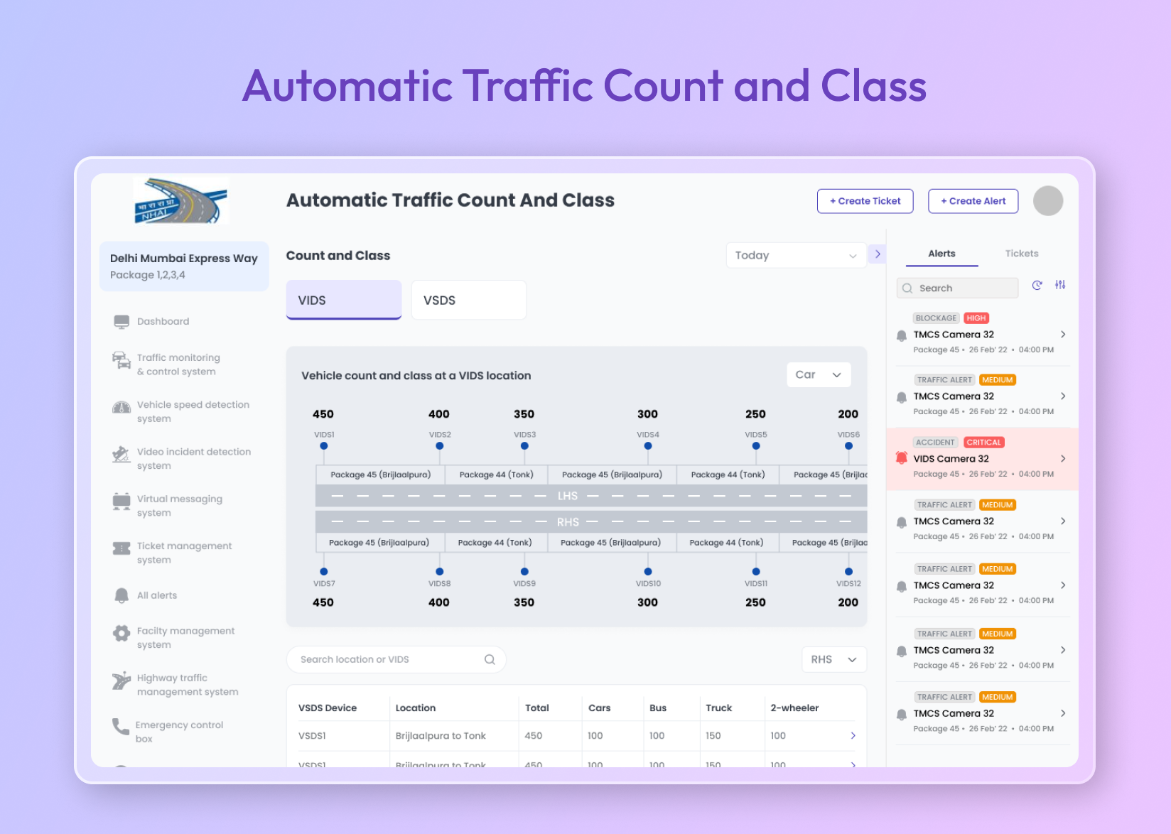
8. Automatic Traffic Count & Classification- Vehicle counting and classification is automatically done by the ATCC module. All vehicle types on highways are recorded for monitoring and data collection at the ATMS Control Centre using data from ANPR and VIDS cameras.
9. Travel Time Measurement System- Travel times and speeds between major project sections are measured by the Travel Time Measurement System (TTMS) using ANPR cameras at VSDS locations. Images of vehicles are captured, numbers are extracted, and time and location stamps are used for speed calculations.
10. Report Generation Module– Key reports for traffic management, including the Alerts Report for incident tracking, the ATCC Report for vehicle data, the Event Report for significant occurrences, the Device Malfunction Report for equipment performance, and the IP Address Master Report for network device management, are generated by the system.
11. Advanced Driver Assistance System- To prevent deaths and injuries that occur in car accidents, this module has been developed. It is installed on vehicle tabs and can detect nearby obstacles or driver errors. It offers multiple screens such as a camera screen, map screen, vehicle details screen, call screen, alert and ticket screen.
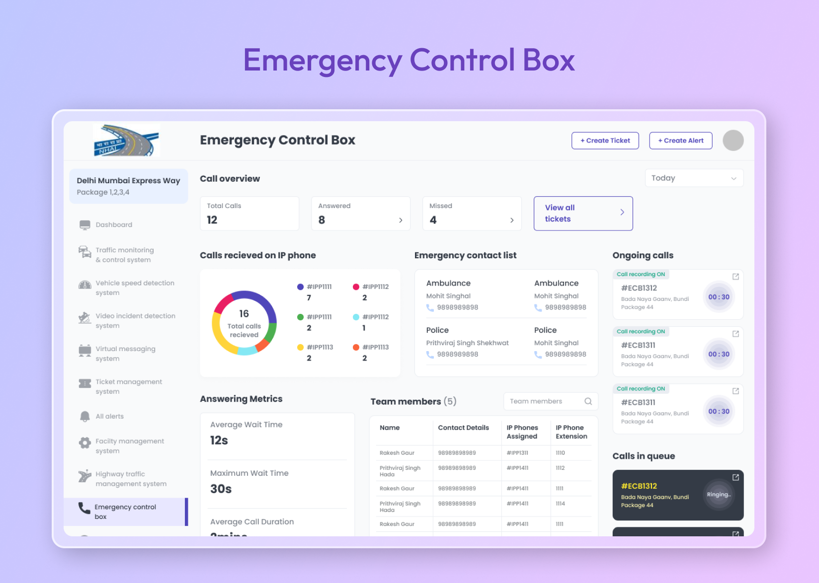
12. Emergency Calling Box- Roadside assistance during emergencies is provided by the Emergency Calling Box (ECB). It is linked to a control center that receives calls from the ECB, telecom providers, and the 1033 service. When a call is initiated, it is processed by the server and handled by the SDK to ensure swift communication.
13. Video Management System- Extensive highway surveillance is offered by VAMS through live and recorded videos from connected cameras. Camera details including alarms, events, and configurations can be accessed by users. Various events are recognized by the system for effective surveillance.
Our team successfully implemented all the 13 Modules of Advanced Traffic Management System (ATMS) on the Delhi-Mumbai Expressway, inaugurated by Prime Minister Shri Narendra Modi on February 12, 2023.
Project Outcome
- Swift response times to emergencies and accidents, reducing incident reporting times by over 480 seconds.
- Enhanced convenience for road users through smoother traffic flow and reduced delays, improving traffic coordination.
- Increased road safety by providing real-time traffic data, helping authorities manage traffic conditions effectively.
- Scalability and adaptability, allowing nationwide application to improve road safety across India’s highways.
Related Case Studies

SLA Financials

